

The doors to the Arctic burst open in mid-January, allowing bitter cold to plunge southward across the United States. The brutal cold obliterated thousands of records, including hundreds of monthly and dozens of all-time temperature records.
Accompanying the bitter cold, episodes of severe winter weather conditions broke out across many regions of the U.S., including those unaccustomed to the hazards of winter weather. Videos of vehicles sliding across icy roads and people finding creative ways to safely cross icy surfaces were aplenty on social media.
Seemingly, every time winter’s fury is unleashed, arguments citing the severe winter conditions as evidence of the lack of global warming mount on social media. However, climate scientists refute these arguments, with Roberta Boscolo, the climate and energy lead at the World Meteorological Organization (WMO) stating the following on LinkedIn, “I must emphasize: these cold events do not contradict the reality of #globalwarming.”
January 2024’s cold by the numbers
As of Jan. 25, a total of 2,377 daily low max-temperature records and 1,766 daily low min-temperature records have been set this month across the United States, according to the National Centers for Environmental Information (NCEI).
Amid the extreme cold, 345 monthly cold temperature records have been observed in the U.S. so far this January, and a total of 80 all-time low-temperature records were smashed. For instance, Saco, Montana, located in the northern part of the state, recorded an all-time low temperature of 51 degrees below zero Fahrenheit on Jan. 14.
The culprit behind the cold
Before the freezing weather across much of the U.S., warming in the stratosphere, the layer above Earth’s atmosphere, occurred in the Arctic region. That disrupted westerly winds known as the polar vortex, which typically keep frigid air locked up over the North Pole. An amplified polar jet stream was set into motion, surging southward across the Lower 48 states, and thus, bringing polar air with it.

Climate realities and the future of extreme cold
The record-shattering cold and severe winter weather “highlight the dynamic complexity of our #climate system,” Boscolo explained.
“Earth has just experienced its hottest year on record, and while the frequency of extreme cold events is decreasing due to global warming, the intensity of such events remains a subject of study. While we can expect fewer severe cold events in the future, regions must remain vigilant and prepared for exceptional cold spells,” she added.
On Wednesday, Climate Central, an independent group of scientists and communicators, released a report on how cold weather is changing amid a warming climate.
“While extreme and dangerous cold events like last week’s still occur in a warming world, cold extremes are generally becoming less frequent and milder across the U.S.,” Climate Central stated, adding that exceptional cold outbreaks are also becoming shorter.
The temperature on the coldest day of the year has increased by 7 degrees Fahrenheit on average since 1970, according to Climate Central’s analysis of 242 locations in the U.S. The most notable change to the coldest days has been felt on average in the Ohio Valley, 8.7 F, and the Northwest, 8.4 F.
“Despite the recent blast of Arctic air, the longer-term trends (monthly, yearly, decadal) have been consistently above normal,” Brett Anderson, AccuWeather senior meteorologist and climate change blogger, said. “Even in a warming climate, there will still be periods of extreme cold, but they will become less common this century. In a warming climate, the air can hold more moisture, thus storms will have a greater capability to produce heavier precipitation, whether it is rain or snow.”
“Though, with the warming, the occurrence of snowy days is clearly on the decline, but that does not mean we still cannot get blockbuster snowstorms every now and then,” Anderson added.
Studies have shown that the rapid warming of the Arctic may favor more “blocking” events, which can, in turn, lead to more intense storms that move slower and unleash more intense precipitation, Anderson explained.
“The lack of snow and ice cover [in the Arctic], which has been in steady decline, favors more heat being accumulated near the surface,” he said. “As the warmer air rises, the pressure aloft rises, perhaps favoring more high-pressure blocking patterns in the high latitudes. These blocking patterns also tend to slow the jet stream, which in turn means slower-moving and potentially more intense storms that can produce extreme precipitation for a longer period of time.”
Anderson echoed Climate Central’s findings, noting that extreme cold outbreaks will continue to be in decline and the coldest waves of air will trend milder than those of the 20th century.
The effects of less frequent and shorter cold intrusions have real-world implications on health, including seasonal allergies, and agriculture, especially sensitive crops like fruit trees, to name a few.
Big pattern change underway in the US
Milder air returned to much of the U.S. this week. Widespread wet weather has led to flooding across Southern states, with more rain on the way into the weekend. As warmer air surged over the cold and in some areas, snow-covered ground, dense fog blanketed the central and eastern parts of the country. In fact, the nation experienced its most widespread dense fog since October 2005.
A moisture-laden storm will spread torrential rain from the Gulf Coast states to the Appalachians on Saturday. On the colder northern and western flank of the storm, a heavy snowfall of 3 to 6 inches with locally higher amounts will occur from northern Pennsylvania and southern New York to southeastern Maine and central Massachusetts from Sunday into Monday. Major cities along the I-95 corridor will mostly face soaking rain and the threat of localized flooding, but a changeover to a wintry mix or snow is possible for some before precipitation ends.
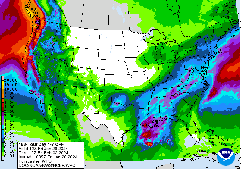
Next week, the focus of stormy weather will shift by midweek, with an atmospheric river predicted to unload significant rainfall from Washington to Northern California.
Some quick highlights:
- Several inches of rain, upwards of 4 inches with locally higher amounts, will drench coastal areas of Washington, Oregon and Northern California, leading to the potential for flash flooding.
- Rain will eventually sweep southward to Southern California, including in Los Angeles and San Diego, by late in the week into the weekend.
- The pattern is closely resembling a typical El Niño setup in wintertime, which can bring wet weather to California and the South.
